Wednesday, October 31, 2012

Arctic Mine

 On the way to the trailhead, our carpool just missed hitting a young bear which was loping across highway 20.  Quite an amazing sight!


camouflaged
ball mill
Twelve of us hiked up the Arctic Mine for the first time since June of  '09...you can check the old posting and see if you were there.  This time the weather was a lot cooler but other than that, the hike was similar.  Arctic Mine is accessed by Maybert Rd in Washington.  Some of us parked at the Gold Quartz picnic area and we hiked up the dirt road from there.  At Canyon Creek the bridge was out just as last time and just as last time John and Frank (this time) made a bridge over the boulders with a heavy plank that was lying around.  After we crossed, we pulled up the plank so no one could disassemble the bridge.  Arctic Mine is at the head of the canyon and made a good place for lunch with its Canyon Creek view and the steep black high rock outcroppings that narrowed the canyon.

After lunch a few of us decided to explore up further.  The trail was on an old steep road.  We went up fairly high, almost to a pass that would take us to Bowman Lake, many miles away.  The rest of the group went back to the creek where some reconstructed the bridge and thankfully left it there for the rest of us.  We all returned to the cars at about 3, having hiked 7 or 8 miles.

walking the plank
Next week there will probably be two hikes.  One will meet at the usual place at 9 and possibly to Rice Crossing.  The other will meet at our house at 9 and go out by Colfax to the American River.  The hike will be steep with a challenging river crossing (plank with no rails) at one point.  I have included Frank's description:


Ellen and I have hiked most of this, but not all. On the attached map (Canyon Creek.JPG) there is a road going to point #2. We have hiked most of that during the winter with snow on the ground. We have hiked from the end to point #1 when we realized that things didn’t look familiar so I turned on the GPS and found us way off course. We turned back and walked across the Gravel Mine where we really did not belong. Looking at the little GPS screen we did not realize how close we were to the road. This is a fascinating hike with a number of slot canyons deep pools and waterfalls. I have not been all the way down to the American River because it was VERY hot the day we hiked this. When we first cross the Canyon Creek a 2x12 crosses a narrow canyon with rushing water below. For many, this is a very scary crossing. I’ve also attached a land ownership map showing what land is owned by the BLM (yellow) The following two links describe this trail much better than I could.
 

Thursday, October 25, 2012

Rice's Crossing

wild grapes


pokeweed
was it raining in GV?
Cautiously optimistic, three of us decided to hike somewhere that had a covered lunch table.  We parked at Buttermilk Trailhead and hiked up the hill, down to Rice crossing, and back to the confluence of the two forks of the Yuba.  We didn't even need the covered table and most of our hike had been between raindrops.  After lunch we went back to the covered bridge and explored the other side of the river.  We quickly found out why we had seen so many bear droppings:  ripe wild grapes and pokeweed berries.  Also we were surprised to see a tall pine that had what looked like a new lightning scar.  With all our side trips we had hiked 8 plus miles. 
lightning tree
 

Thursday, October 18, 2012

Buzzard's Roost

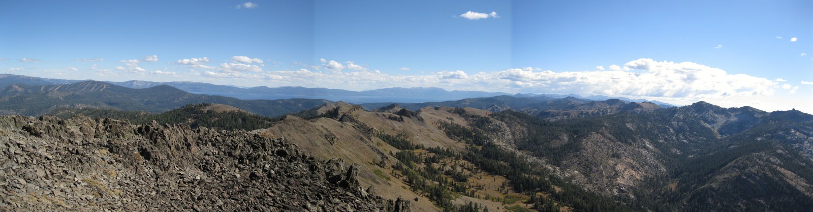
Once again the 8 o'clock group ventured into new territory, this time exploring Rattlesnake Road further.  Five of us bounced along in our high-clearance truck over Magonigal Summit towards Upper Montez Lake.  We parked at Lily Pond in order to do a loop up Buzzard Roost (8096), over to it's lake, and back.  The many dirt roads in the area are thick with dust at this time of year so it was a relief to head straight up the little mountain away from the road.  The views to the south were of the Route 80 valley and Devil's Peak and Snow Mountain.  Castle and Basin Peaks and Mt. Lola were easily visible as well to the east and north.  Once again we were surrounded by beautiful granite outcroppings and gnarled trees: mountain hemlock, fir, pine, and juniper.

Buzzard Roost Lake

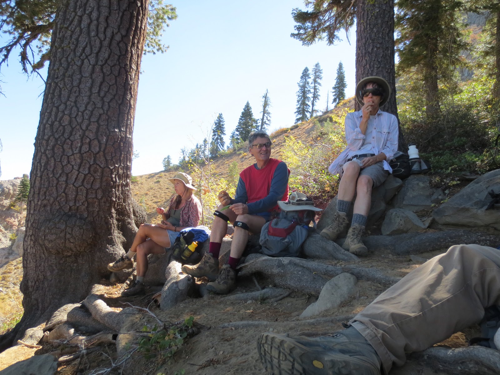
We descended the other side going cross-country through, up, over, down from the large granite rocks that grace the landscape. We came across a remarkable volcanic flow of andesite that covered several acres and surprised and delighted our geologist fellow hiker.  Finally we went down a very long, smooth descent that ended up at the lake where we found a beautiful cabin.  We ate lunch in the idyllic setting, hoping to see the rumored fish that were supposed to be there but saw nary a one.  The weather was perfect and we could have stayed but we left by a very rough road that the cabin owners had apparently built for access.  How they naviagated it made us wonder at the size and shape of their vehicles.  It looked challenging to say the least. 

We then moved the truck a mile to the Upper Lola Montez Lake area.  As the lake was only a stroll from the truck, I stayed there (asthma problems), painting a picture and exploring. The rest of the group left to find the actual hole of the "Hole in the Ground" trail closeby.  However, as John relates, they became sidetracked, first by a scramble up some beautiful granite to admire the views of Lower Lola Montez Lake, then by another lava flow about a mile away. It took only about half an hour to make their way over to it, thanks in part to one of the many 4WD roads that wend their way around this country.  Our geologist companion explained that this second flow was a basaltic flow creating a table mountain-type of plateau with a sheer dropoff on it's terminal edge. The flow is visible from I-80, and is remarkable to walk on with a surface resembling crushed rock.  Large granite boulders are scattered about, left by the glacier.
Upper Lola Montez Lake

We returned to the truck and headed back on the long drive back to the Cisco Grove onramp, which, we discovered, was closed, forcing us to head east a couple of exits before we could enter the westbound lanes.  We returned via Colfax again due to the continued closure of the Hwy. 20 offramp.  This time, no deer encounters.

We hiked about 8.5 miles total, 1700 foot elevation gain.

Next week, depending on the weather, we hope to hike in the Gold Lakes area.  We will possibly stop for dinner in Sierra City, if the terrace is still open.  But who knows with the weather forecast?

Old Juniper

Thursday, October 11, 2012

Tinker's Knob

Tinker Knob from lunch spot
Five 8 o'clockers started the trailhead at horseshoe bend in Cold Stream Canyon, trying once again get to Tinker Knob, visible off in the distance above the riverbed.  While there were yellow aspens down low, we quickly lost them as we headed up the dusty road. About a mile in we came across the charming Lost Trail Lodge.  It looked beautifully kept up but all we encountered was their large and friendly dogs.  Passing by, we bade the dogs to stay as we started the long slog UP.  Much of the road looked well traveled by OHV's and mountain bikes but, except for a single runner and her dog, we encountered no one on our long ascent. 

On Tinker Summit

Looking north on PCT to Anderson Peak

The road became a single track and the views opened up.  We were climbing up a ridge that was roughly parallel to the divide.  We could see multiple peaks as well as Benson Hut, about a mile away by crow flight.  The terrain was beautiful, if a bit dry and dusty, typical of the Sierra's east side.  Lodgepole pines and granite boulders, dry rattling mule's ears, blue sky dotted with light clouds, and views to knock your socks off.  The trail had came out of Cold Stream Canyon and across a ridge to connect up to the PCT just below Tinker Knob.  A cold wind made us bundle up and seek shelter in order to eat some late lunch.  Even so the wind found it's way to our bones and we lingered only a short while.  While sitting there, though, we saw a bald eagle fly by rather close and a pair of through hikers with enormous packs hiking north. 

Looking south on PCT to Granite Chief and Squaw
Summit
Trail
After lunch we decided to hike the short way up the PCT to get closer to Tinker Knob.  A few flowers were in bloom this late in the season: Sierra Rocket and paint brush.   Lo and behold, there was a trail branching off of the PCT that appeared to go up the rocks to the summit.  We had better luck than the previous weeks on Devil's Peak and quickly scrambled to the top!!  And what a reward.  Not nearly as much wind and 360 degree views of every peak  around - even through the autumn haze.  We could see the Sierra Buttes to mountains on the other side of Heavenly, far mountains to the west and east into Nevada.  Lake Tahoe was quite visible.  It was interesting to figure how the PCT avoided the crest just south of us (way too steep) and went into the headwaters of the American River Canyon and up the other side to where we had had lunch several weeks previously (Granite Chief/Squaw hike).  North, we could see how the PCT went to Anderson Peak which is somewhat low and insignificant from our viewpoint at 8950 feet, even though it is imposing from Benson.  It appeared that the through hikers we had seen earlier were on top of Anderson when we departed.  The hike down was fairly rapid and, after exploring the fabulous lodge and it's pictures and decor, we got to meet the proprietors, an enthusiastic young couple and their 7 year old daughter.  They were walking back from the woods where they had been working on a home school project about planets and the scale of our solar system.


Peaks to South
So it was another fantastic hike of this summer of great hikes - new and unexplored (by us) - nice and long - 12.5 miles and 2680 foot elevation gain/loss, although dark by the time we returned home.  John's skillful driving narrowly saved us all from a violent encounter with a couple of large deer on 174 (hwy 20 ramp was closed).  We almost got rear-ended when he slammed on the brakes. 

Next week (if the weather holds) the 8 o'clockers will explore the Buzzard's Roost area (Sterling Lake "road") - much of the hike will be off trail.

From lunch spot
 Pictures by Frank and Elly


low down in the aspens

Thursday, October 4, 2012

Devil's Peak redux

Seven of us headed to Devil's Peak from the Kingsvale exit.  First we messed around on Troy Rd., crossed the RR tracks and came to a gate.  It was private property and we were divided about whether or not to tresspass.  The road became beautifully paved at that point and maybe it led to an estate.  Estate of a timber company baron?  The dirt road up to that point was fairly easy except for fording a rocky stream bed.  So we returned to the Kingsvale exit and went straight towards the Shell station, parking in the right side of the lot.  The dirt road we were looking for was blocked by hills of dumped roadbed so we walked up.  It wasn't a road suitable for a Subaru off road experience, anyway. 


We hiked up the steep inclines, past a rusted out old rope-tow and up to the RR tracks.  There, we could see a canyon made by the outflow of the Cascade Lakes.  There appeared to be trails up either side of the flowing cataracts and we chose the one on the far side of the RR trestle.  We were in a wonderland of falls soon culminating in water cascading over what appeared to be a fairly recently constructed dam, creating a beautiful small lake with folding chairs on the shore and strange wooden structures that resembled mini-skiboat jumps.  Not a soul around, but it appeared to be someone's idyllic swimming hole.  We continued up the canyon in the general direction of Devil's Peak and fairly soon came to a dirt road/trail that eventually connected with that very same road we had seen at Troy Road.  What?  All that off-trail hiking to come to a road more beautifully asphalted that the one we live on?  To our wonderment, the road led to the most carefully logged woods we had ever seen.  Trees had been limbed up and slash had been chipped, creating a park-like effect.  Was this the legacy of the bankrupt owners of Royal Gorge?  The work of that mythical lumber baron, one with a very progressive forest management philosophy?  Who knows, but it was beautiful to behold.


Coming down by the seat of his pants!
 
So back to the business of  climbing that columnar basalt monolith.  We headed UP steeply towards a particular spot because now we were also going after a geo-cache.  Amazingly, we ran into a couple of GV guys who had been defeated in their quest for the top.  They had come in on the forbidden road by bicycle and, like us, were merely exploring.  Not long after we separated, we, too were defeated.  For every step up, we had a slide down - the dust was thick, the rocks were loose and tumbling and in the back of our minds was worrying about how we would make our safe return DOWN. 


We did make it downslope with only a few minor mishaps and no injuries, and proceded to cut across the woods over to the paved road and followed it as it wended it's way past the Horseshoe warming hut, which looked pretty humble compared to its winter splendor.  For the future,  it looks like the best way to get higher up the peak - I don't know how high - would be to start our ascent at this warming hut. It appears there are easier ascending routes from here - but who knows?  Easiest way to get there is to take the Pahatsi Road entrance to Royal Gorge, park at the Devil's Outlook warming hut above Cascade Lake, and hike directly to the Horseshoe warming hut.  We would take "Wagon Train" to the famed paved road.  At least that's how it shows on the ski map. 

We returned the way we came, humbled a bit by our second failure to climb this tough mountain, but thrilled by another great day hiking our "backyard".  How lucky we are to live here!

Next week: perhaps a second attempt at Tinker's Knob, this time starting at the horseshoe bend out of Truckee/Donner Lake.  It could be a looooooong hike, who knows?

Top 3 images from Frank.

Followers

Blog Archive