 |
| Tinker Knob from lunch spot |
Five 8 o'clockers started the trailhead at horseshoe bend in Cold Stream Canyon, trying once again get to Tinker Knob, visible off in the distance above the riverbed. While there were yellow aspens down low, we quickly lost them as we headed up the dusty road. About a mile in we came across the charming Lost Trail Lodge. It looked beautifully kept up but all we encountered was their large and friendly dogs. Passing by, we bade the dogs to stay as we started the long slog UP. Much of the road looked well traveled by OHV's and mountain bikes but, except for a single runner and her dog, we encountered no one on our long ascent.
 |
| On Tinker Summit |
 |
| Looking north on PCT to Anderson Peak |
The road became a single track and the views opened up. We were climbing up a ridge that was roughly parallel to the divide. We could see multiple peaks as well as Benson Hut, about a mile away by crow flight. The terrain was beautiful, if a bit dry and dusty, typical of the Sierra's east side. Lodgepole pines and granite boulders, dry rattling mule's ears, blue sky dotted with light clouds, and views to knock your socks off. The trail had came out of Cold Stream Canyon and across a ridge to connect up to the PCT just below Tinker Knob. A cold wind made us bundle up and seek shelter in order to eat some late lunch. Even so the wind found it's way to our bones and we lingered only a short while. While sitting there, though, we saw a bald eagle fly by rather close and a pair of through hikers with enormous packs hiking north.
 |
| Looking south on PCT to Granite Chief and Squaw |
 |
| Summit |
 |
| Trail |

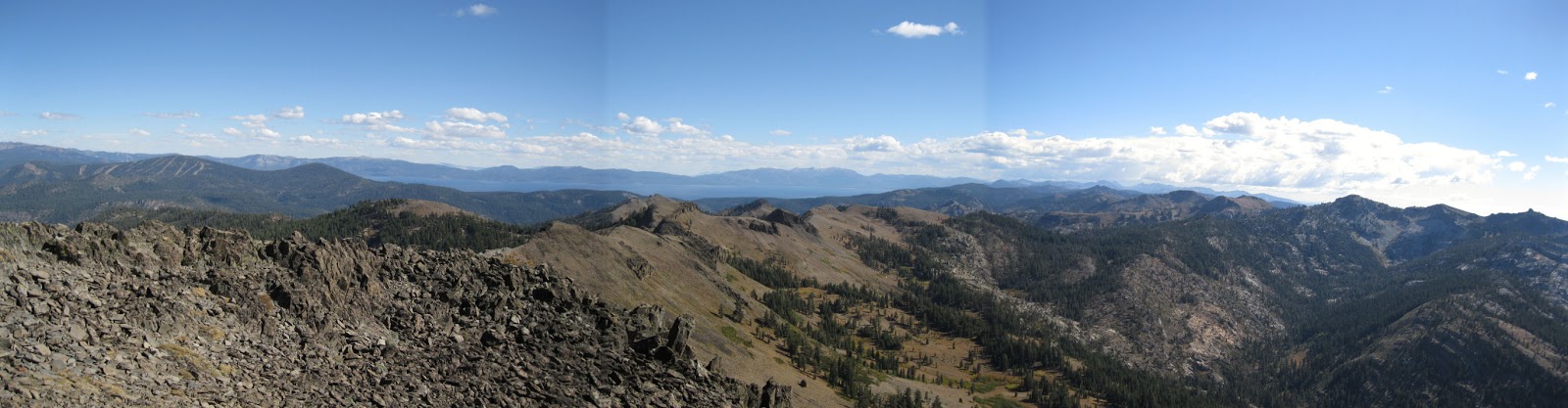
After lunch we decided to hike the short way up the PCT to get closer to Tinker Knob. A few flowers were in bloom this late in the season: Sierra Rocket and paint brush. Lo and behold, there was a trail branching off of the PCT that appeared to go up the rocks to the summit. We had better luck than the previous weeks on Devil's Peak and quickly scrambled to the top!! And what a reward. Not nearly as much wind and 360 degree views of every peak around - even through the autumn haze. We could see the Sierra Buttes to mountains on the other side of Heavenly, far mountains to the west and east into Nevada. Lake Tahoe was quite visible. It was interesting to figure how the PCT avoided the crest just south of us (way too steep) and went into the headwaters of the American River Canyon and up the other side to where we had had lunch several weeks previously (Granite Chief/Squaw hike). North, we could see how the PCT went to Anderson Peak which is somewhat low and insignificant from our viewpoint at 8950 feet, even though it is imposing from Benson. It appeared that the through hikers we had seen earlier were on top of Anderson when we departed. The hike down was fairly rapid and, after exploring the fabulous lodge and it's pictures and decor, we got to meet the proprietors, an enthusiastic young couple and their 7 year old daughter. They were walking back from the woods where they had been working on a home school project about planets and the scale of our solar system.
 |
| Peaks to South |
So it was another fantastic hike of this summer of great hikes - new and unexplored (by us) - nice and long - 12.5 miles and 2680 foot elevation gain/loss, although dark by the time we returned home. John's skillful driving narrowly saved us all from a violent encounter with a couple of large deer on 174 (hwy 20 ramp was closed). We almost got rear-ended when he slammed on the brakes.
Next week (if the weather holds) the 8 o'clockers will explore the Buzzard's Roost area (Sterling Lake "road") - much of the hike will be off trail.
 |
| From lunch spot |
Pictures by Frank and Elly
 |
| low down in the aspens |


 After lunch we decided to hike the short way up the PCT to get closer to Tinker Knob. A few flowers were in bloom this late in the season: Sierra Rocket and paint brush. Lo and behold, there was a trail branching off of the PCT that appeared to go up the rocks to the summit. We had better luck than the previous weeks on Devil's Peak and quickly scrambled to the top!! And what a reward. Not nearly as much wind and 360 degree views of every peak around - even through the autumn haze. We could see the Sierra Buttes to mountains on the other side of Heavenly, far mountains to the west and east into Nevada. Lake Tahoe was quite visible. It was interesting to figure how the PCT avoided the crest just south of us (way too steep) and went into the headwaters of the American River Canyon and up the other side to where we had had lunch several weeks previously (Granite Chief/Squaw hike). North, we could see how the PCT went to Anderson Peak which is somewhat low and insignificant from our viewpoint at 8950 feet, even though it is imposing from Benson. It appeared that the through hikers we had seen earlier were on top of Anderson when we departed. The hike down was fairly rapid and, after exploring the fabulous lodge and it's pictures and decor, we got to meet the proprietors, an enthusiastic young couple and their 7 year old daughter. They were walking back from the woods where they had been working on a home school project about planets and the scale of our solar system.


No comments:
Post a Comment