Wednesday, March 12, 2014

Gold Run Canyon Creek

Twelve of us headed to the Gold Run exit to try to find the plank crossing Canyon Creek we had crossed another year.  This time we would be more efficient as surely, we knew the correct trails.  But as luck would have it, we goofed again heading too far the other way from the ditch path.  We did see the huge drainage tunnel but this time we entered it from above rather than from below.  Frank pointed out the carbonized wood imbedded in the ceiling. 

We finally made it to the second tunnel and Canyon Creek.  A goodly number of hikers had no interest in going further to the plank bridge.  But Frank ran down there during lunch and verified it's existence, so we will try again with the smaller group.  The goal is to go down to the American River once we cross the creek.  We could see the trail on the way back.

Some of the trail was steep enough to either sit or be helped down.

Part of Canyon Creek comes out of this tunnel.
Today's hike was 5.3 miles with a 1163 ft. elevation gain.


We are still thinking about next week.  Right now we are considering a snowshoe hike  because one of our members got them for Christmas and has yet to use them.  We would hike the 3 Ladies starting at Boreal and will meet at the usual   place at 9 as the snow will be too icy if we arrive too early. 

Thursday, February 20, 2014

Gracie Ditch

 On a gray, misty morning, six of us decided it was going to be too cold and wet to sit down for a picnic so we opted for a tried and true local hike.  Nine miles of brisk walking goes by quickly so that we all felt it in our joints.  Otherwise uneventful, the hike had a few interesting diversions:  a couple of "dirt baggers" geocaching with various equipment, a controlled burn,  a couple of NID workers checking meters, and a few pups.

Next week there is some talk about doing the tombstones to accommodate Karen who has been suffering from sciatica.  There is also some talk about snowshoeing at the Three Ladies if the weather cooperates and brings some actual snow.


Wednesday, January 8, 2014

Lake Valley Reservoir

Seven of us, wanting a semi-high country hike, decided to hike at Lake Valley Reservoir where route 20 meets 80.  The road in was icy from the snow so many weeks ago so we were glad we had either a four-wheel or all-wheel vehicle.  Right away we were hiking through large patches of snow which grew deeper on the more protected slopes near the cabin.  The going was sometimes tiring from the post-holing effect of our hiking boots. 

Reaching the overlook by 11 AM, we decided to ascent the dome behind it.  Not wanting to go into deeper snow and brush we first climbed part way up the lower dome that seemed to merge into the larger one.  This proved difficult due to the snow's slipper effect on the rocks.  Using all fours, we crawled up the larger dome, trying to avoid icy areas.  Once on top, we ate our lunch in a cold wind blowing off the lakes below. 

Figuring our descent was going to be tricky, we went off the back of the dome curving to the left.  That left us stranded on a cliff looking down at the road we wanted to take back.  So we turned around and ascended again, tromping through pokey brush, rocks, and snow to get to a spot we had been to before.  From there, we descended mostly through brush and into the forest of fallen trees. 

Then we headed back down the snowy trail to the icy lake.  We had only hiked about 5.5 miles with a bit over a 1K elevation gain but we felt like we had had quite a workout. 

So, 9 o'clockers, maybe you made the right decision to turn around and hike the Pioneer trail.  Our hike was tricky and difficult in parts as we twisted and turned to get proper handholds, to not get poked by brush, and not slide off of the rocks.  But we did have fun...especially the slidey part.


Wednesday, January 1, 2014

Some Hikes

Three Hikes
They haven't been recorded but here they are:

 Fairy Falls - We went with the 9 AM group. 

Cronan Ranch -


Kayakers pulled up at Cronan Ranch on the American River.
Four of us greeted the New Year with an 8 mile hike at the confluence of the American River. 
We were quite surprised at the  number of hikers below Lake Clementine.
I guess we are not used to Wednesday being a holiday.
And yes, they were checking for payment at the car park. 

Friday, December 6, 2013

Rice's Crossing

South Fork meets Englebright


Five of us headed off to Bridgeport to take one of the sunnier hikes we could think of.  It did not disappoint and although we started with warmer outerwear, we found we discard the jackets by mid-morning.  Our route was down to the crossing, back up and then down to Point Defiance for an early lunch.  Then we walked back to Bridgeport along the Yuba.  We cross-countried up the steep hill at the end to meet the trail that leads back to the top.  6+ miles, -1K elevation gain. 
Middlefork flowing fast

Englebright


S. Fork

Wednesday, November 27, 2013

S Yuba

E
From last week: Gracie Ditch, NC

Big Bend

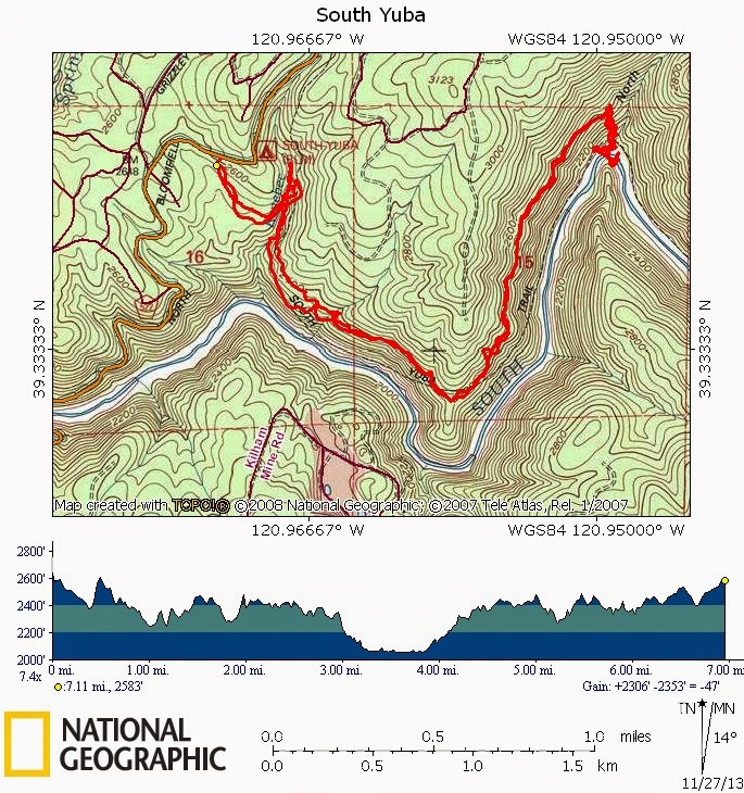
 Eleven (?) of us went on a short quick hike down to the S. Yuba from the campground on the other side of Edwards Crossing.  It was disturbing to us that the river was so low. 


Dead but propped up: Varied Thrush

Wednesday, November 13, 2013

Ice Lakes to Crow's Nest

fingers courtesy of Frank
Seven of us went up to explore Royal Gorge further on the opposite end from Devil's Peak.  We passed Ice Lakes Lodge and found ourselves on a well-maintained dirt Forest Service road.  Not knowing where to start the hike, we explored some areas by car, enjoying the long view into the deep gorge of the American River.  Anderson Peak and Tinker's Knob were before us, as were many other unidentified peaks.  A pick up and a rented U-Haul van passed us so we thought that it would be fun to explore that road further at some other time.  We started the hike on an unnamed jeep road that headed steeply up the back of the ridge I wanted to hike on.  Sometimes bush-whacking, we kept wending our way to the ridge and were rewarded with incredible views.  Unfortunately there was heavy smoke to our northeast, beyond Castle Peak, which we hoped was a controlled burn. 

We decided to eat lunch on the ridge near a dramatic volcanic extrusion.  The rocks were weathered much in the same fashion as the rocks on the trail between Castle and Basin Peaks.  The forms are sculptural, resembling sentinels.

Devil's Peak
We went on towards the Sugar Bowl peaks between us and the PCT.  We only made it up to the nearest one, called Crow's Nest, a steep climb in snow that offered incredible views all the way up.  At the top there was a rock scramble to the very top and much to our amazement we were right on top of a brand new looking ski lift.  Mt. Disney, Mt. Lincoln and Mt. Judah were in front of us, giving us ideas for another hike. 

This was another exciting exploration hike in a summer full of them. And it's mid November, for heavens sake!  If we hadn't spent so much time exploring the road at the beginning, we would have had more time for getting up Disney as well.  Next week?

We hiked about 7.5 miles with an elevation gain of 1826 feet, highest peak being 7849.
Blue trace is today's hike


From the top of The Crow's Nest

Followers

Blog Archive